> see also Photogallery n°15 and video dedicated to the group at Project Iceberg
Terry Wilson (Ohio State University – Ohio – USA)
Tim Paulsen (University of Wisconsin – Oshkosh – USA)
Andreas Laufer (Federal Institute of Geoscience & Natural Resources – Hannover – Germania)
Cristina Millan (Ohio State University – Ohio – USA)
Out of all the groups this one is the first to see the core (see also work flowsheet). They are so committed to the job that their laboratory is located just beside the drilling platform (see also photogallery n°15). The cores are passed through a window from the hands of the drilling workers straight to the researchers.
What’s analysed?
The core of material (that may contain sediments and/or rocks and/or water) as a whole, as extracted from the drilling pit. Both the external surface macroscopic features and some physical parameters are collected.
Which analyses are carried out?
The analyses concerning the external surface mainly consist in surface scanning by means of a special 3D scanner that converts the data into a 2D high resolution digital image (100 pixels for every scanned centimetre, see photogallery n°15). With this technology it is thus possible to study every detail on the surface in a more practical and precise way compared to direct observation of the core. The image is managed by a special software called ‘Corealyzer’.
Several physical measurements are done: they range from simple ones to complex measurements. The complete list is as follows:
- exact dimensions, both length and width (thickness)
- speed of seismic waves P (every centimetre)
- wet bulk density (every centimetre)
- electrical resisitivity (every centimetre)
- magnetic susceptibility (every centimetre)
In this phase, further operations are carried out with the purpose of reconstructing the original orientation of the core, that, as you might already know, has been spun many times during the drilling operations. Again, during this phase the core is cut in 1 metre-long segments.
How are analyses carried out?

The scans are performed by a special 3D scanner (DMT core scanner <manufacturer’s web page>), equipped with a cylinder (on which the core is laid) and an overhead sensor for illumination and image acquisition. The data are imported in digital form and processed by a suitable software (Corealyzer).
All the physical measurements are completed by means of a single instrument (called “Multi Sensor Core Logger”, MSCL) that retains all the sensors required for the different measurements. Here is a list of all the physical measurement data the instrument is capable of collecting:
Velocity of seismic waves P (symbol, Vp) is measured with an ultrasound sensor using a 500 Hz wave frequency. The parameter gives an estimate of seismic wave speed in the one centimetre portion of core analysed. The unit of measurement is m/s.
Density (symbol: d) is determined by means of an device that irradiates the sample with gamma-rays: density can be calculated from the portion of rays absorbed by the sample. Water has the lowest density, then (in general) sedimentary rocks follow, with volcanic rocks displaying the highest density. The unit of measurement is g/cm3.
Electrical resisitivity is reciprocal to electrical conductivity. The parameter is related to the water content of the core: the more water present in the cm portion analysed, the lower the resistance to electricity transit (higher electrical conductivity). The unit of measurement is Ohm ().
Magnetic susceptibility gives an estimate of the quantity of minerals (especially magnetite) sensitive to the magnetic field at a specific location on the core. Volume magnetic susceptibility is unit-less in SI (International System).
What is found out?
 The detailed examination of the core surface allows the discovery of faults, folds and cracks.
Each of these structures can be observed on the core surface and some of them might affirm the presence of the same structures in the original rocks. However a problem must be solved: during the drilling operations the core has been spun many times. How can we determine its original layout and orientation? This problem, called “Core orientation” has no easy solution and is solved through various methods, one of which consists of sending a video camera down the pit to record images of the its internal walls. For the same purpose as soon as the core is extracted, two longitudinal lines opposite each other, one blue and one red, are drawn along it (see also photogallery n° 15).
 Analysis of physical properties provide useful indications for the investigations which follow: magnetic susceptibility is used for paleomagnetic analysis; density is related (in addition to the water content) to the mineral content at the time the rocks were formed.
Many of these data are compared to the seismic data collected during the surveying explorations (see section “The choice of the site”) with the purpose of reviewing the preliminary decisions taken during site choice process.
The data collected from both the inspection of the core surface and the physical measurements are interpreted according to the geology of the area. For instance a sedimentary structure may show the direction of ancient water streams. Folds and faults may reveal older or more recent stress lines in the Earth’s crust. Other structures may indicate how the sediment erosion evolved, and very importantly, traces of remote glacial changes can be found. All this information is cross-referenced with that obtained from other disciplines, such as micropaleontology, sedimentology and petrography to provide an overall interpretation of the geological history of the area.
Case studies
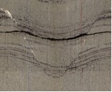
The range of values is the same in all the photos: magnetic susceptibility 1 – 1000; density 0-3 g/cm3.
Diamictite

Diamictite 8230-8260 m (below surface)
(Image captured by the Corealyzer screen, see also photogallery n°15)
This rock is formed where the ice platform lies right on the ocean floor. Down here clasts settle chaotically without the typical selection according to granulometry, coarser at the bottom and finer at the top. Diamictite appears as a mixture of clasts with different granulometry and composition. Some of these clasts, in turn, appear to be themselves clasts of a more ancient diamictite. Its physical properties depends on the quantity and quality of the clasts incorporated and can vary considerably. Diamictite is very common in the cores extracted so far (depth -230 m) and can be found in uninterrupted layers up to 30 meters thick.
Volcanic horizon

Volcanic unit 8320-8335 m (below surface)
(Image captured by the Corealyzer screen, see also photogallery n°15)
Volcanic horizons are quite common, given the proximity of Erebus volcano, even if pyroclastic material originating from other volcanoes has been found. Pyroclastic materials are spewed out during an eruption (ashes, lapilli, etc.) and subsequently lithify; this layer in particular, incorporates also some pumices. From a physical property point of view, this type of layer shows a high density and in general (especially if the lava is basic, rich in femic minerals) a high magnetic susceptibility- rich in minerals sensitive to the magnetic field and therefore potentially capable of recording its direction and intensity. This feature is very important for dating.
Biosiliceous sediment

Biosiliceous sediment 8670-8690m (below surface)
(Image captured by the Corealyzer screen, see also photogallery n°15)
This type of deposition is formed by silica of organic origin, the layer shown in this picture is particularly rich in diatoms. It typically originates in an open sea environment (with or without seasonal ice cover), where recurrent dramatic diatom blooms take place. However it may also form below ice platforms, where the sea current carries this diatom-rich water dozens of km away. The resulting sediment shows a very low density and magnetic susceptibility due to its sedimentary-biological origin.