Let’s start by saying that the job of chosing the best drill site, lasted for five years of study and research: just to give you an idea about the complexity of the choice, see on andrill.org some videos of the researches 2005.
The most used method in these situations (thanks to relative moderate cost and the possibility of examining large areas) are seismic surveys. In fixed places they set off explosive; the seismic waves generated are reflected (they rebound) and/or refracted (diverted) according to the different kinds of rocks below. By picking them up with suitable instruments and studying, interpreting them with care, you get a lot of information. All this, together with other knowledges on the geology of the area, let us make the best choice of the site. But you never know for certain!
So, why drill right in that place? We will try to explain in our own way (for a more accurate explanation see the Official Scientific Statement of the project MIS – ANDRILL).
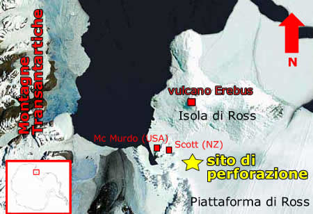
REASON 1. Achilles’ heel
Antarctica is subdivided in two main parts (East and West Antarctica) by the Transantarctic Mountains. In East Antarctica, the immense icecap seats on the continental crust that, for the most part, is above sea level: it is a continental icecap. Instead, in West Antarctica, ice largely covers areas below sea level and, therefore, they form a seacap. Several elements show that this one and ice shelves (Ross, the biggest in the world and Weddell) are the most sensitive portions, to climatic changes, of the whole continent.
This sensitivity is very marked and only now we can understand its purport. It has a double value: on the one hand, it makes them some extraordinary, natural recorders of past climatic changes, but on the other hand, it makes them vulnerable Achilles’ heels, that, unfortunately, seem inevitable. So it is reasonable that the study of what may happen in Antarctica should start from its weak points.
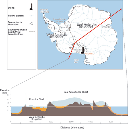
REASON 2. The funnel
The whole Ross platform (as big as France) is an immense collector of ice flowing from the Antarctic continent radially towards every coastline. But the ice reaching the Ross platform comes, for the most part, exactly from West Antarctica, from the portion of cap we are more interested in. Here, on the floor of the Ross Sea, goes, and has gone, a huge quantity of detrita carried by glaciers. By studying them from different points of view (sedimentologic, petrographic), one can get information about glacial flows that moved them (direction, speed, size) and about their source areas.
REASON 3. The deep (phase I)
Where would you dig if you wanted some ancient rocks, whose study could reconstruct the past (a climatic one, in this case)? I am sure that if you were asked, you would answer like this too: in a deep, in a subsidence, in a basin, in a valley. There is the greatest probability that sedimented material keeps a long time and far from agents that could carry it. But keep on reading… At this point geologists are certain: from a geologic point of view, the whole area, where the Ross platform sits, is a rift.
In short, it is a point of earth’s crust stretching and lengthening in opposite directions. Here, according to some researches, there is an earth’s crust (continental) thick only 20 km versus the normal 30 km. It is easy to know that this stretching has also the effect of creating breaks (faults) and lowering crust at some points. In fact, the bathymetry of the Ross Sea shows that some zones of the shoal are real basins: in one of them (called Victoria Land Basin), there is the selected point for the perforation….guess!
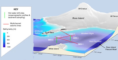
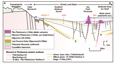
REASON 4. The deep (phase II)
In an open ocean, thousands of metres deep, everything that is deposited can hardly be removed and so the many sedimentary depositions on the oceanic floor are rather continuous as regards time. By analysing these layers it is hard to find “temporal bounds”. Here in Antarctica, instead, there are glaciers, let us not forget it. The very big ones, with their submerged part, can scrape the sea floor and carry away sediments in large quantities. In this case, the kinds of sediments can be very discontinuous with hundreds of thousands years “gaps”
. This, obviously, does not suit: we want to find a special area for our ANDRILL rock core.
The place we are looking for is near the volcano Erebus. It seems that, according to seismic studies, the zone surrounding the volcanic building (one of the greatest for the amount of lava) sank (subsidence) because of a huge quantity of material. In other words, the zone of our drill is a special place, subject to a process of sinking (cracking basin), offering the sediments the possibility to subside, safely, over some millions years.
REASON 5. The watch
Some of the classes involved in the project already know: one of the greatest problems in paleoclimatic studies is dating. That is exactly understand the period or the intermission when the stratum you are studying was deposited. It is a serious problem, with a difficult (sometimes impossible) solution as regards sedimentary rocks.
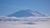
As to volcanic rocks, it is far easier because there is an exact method: dating with isotopes. A volcano near the drill site could be one further advantage: the volcanic material, could be a crucial time reference in order to date the sediments. That is what happened on the 10th of November (read The perforation report). For further information about volcano Erebus, see the educational of New Mexico University, dedicated to the issue and rich of data (also in actual time), videos and audios.
Un pensiero su “Choice of the site”
I commenti sono chiusi.